Wednesday, March 18, 2009

Spring Has To Be Near!!!


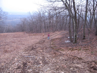
I had the pleasure of hiking the Mt. Tom reservation the other day with Glenn Sullivan, starting at Mountain Park and heading north on the Bray Loop trail through Bray valley up to the Keystone trail and finally up the DOC trail to the MM near Whiting Peak.

The trek was a little muddy as the final patches of snow melt, coupled with the overflow of a few brooks, but with the recent mild weather it was an excellent time to hike and take in the scenery.

The reservation crew has been very busy clearing downed trees, especially on the upper DOC trail
where the winter storms have taken their toll on the forest near Whiting Peak.

Here are a few photos from the top of the range near Mt. Minus.

Saturday, March 14, 2009

Mt. Tom Quarry Canal


Here are a few pictures of the canal or duct that was used to divert water from a brook behind and above the Mt. Tom Quarry. Special thanks to local historian Robert Schwobe for making me aware of this canal and it's location.

Notice that the wooden gate (top picture) is positioned in the slots cut in the concrete to prevent the brook from running in a south easterly direction, to the left of this gate was a concrete wall with slots also (bottom picture) where the wooden gate could be placed to divert the water down the concrete canal to the south east.

I'm sure the canal's diversion of water had something to do with the quarry, since it was built
way before the Ski Area, maybe in the spring months it controlled the run-off of the brook so it wouldn't flood the quarry, i will have to ask Mr. Schwobe about this the next time i see him.

To view this "Mt. Tom Marvel" take the Ski Area road to the quarry entrance, to the right of the entrance, take the hiking trail (this trail runs right behind the quarry parking lot) then take the Knox Extension trail (on your left) to the Quarry Trail, when you get to the Quarry Trail take a left, you will see a fence with the quarry trail sign, this is the end of the Quarry Trail, past the fence follow the trail to it's end, you will see a roped off area with danger signs, don't go past the rope but follow the rope up the mountain and you will come to the top of the quarry ledge, right behind the ledge is the canal, (to get a good idea where it is, look at the second picture, in the background you can see the Mt. Tom Ski Area and Little Mount Tom to the southeast).

Tree Damage At B-17 Memorial


The tree damage at the B-17 Memorial is worse than i previously noted at the Holyoke History Room last week. I was told there were a couple of trees broke at the bottom of the path with one tree laying near the road at the beginning of the memorial path.

On March 14th i was at the Summit Reservoir just south of Dead Top and decided to take a walk down to the memorial via the path from the Pump Station and noticed at least seven Birch trees were broken almost in half, though there was no sign of the broken branches on the ground, i assumed someone had cleaned up the pathway recently and placed some of the broken branches across the trolley road opposite the memorial.

The tree that fell near the road was still there, i believe the damage was caused by the the snow and freezing rain of early February.

The Birch trees were planted at the memorial in honor of the twenty five servicemen who lost their lives in the crash of a converted B-17 transport plane at this site in July of 1946.

Thursday, March 12, 2009

Remembering Mt. Tom Ski Area


After posting pictures and a report of the fire at the Mount Tom ski area last Friday, i've received many e-mails from people who were saddened to hear the news. 

Many recalled the happy times they had spent on the mountain it it's hey-day, one of those e-mails was from CB who was very kind to send me some brochures of the ski area from the 1970s, recalling what a beautiful place we once had atop the mountain (please click on the photo for a larger image).

After looking at these brochures, tell me where in Holyoke can you now have that much fun for those prices?...  No!!!  Mountain Park has been gone for twenty two years!!!

You will also notice the second scan gives a detailed description of the ski area, in the lower left
you can see the former inclined railroad bed that once connected to the Ski Patrol building (14) the sight of Lower Station which was the beginning point of the Mount Tom Railroad.

A couple of questions concerning the last scan, is that Larry Chesky playing the accordion? and who is that pretty girl ?

Thank you CB for giving us a glimpse of what the Ski Area was like once upon a time.

Saturday, March 7, 2009

Mt.Tom Ski Area Fire Aftermath.


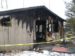
Here's what the so-called First Aid building looked like about 12 hours after the fire Friday night.

I hope and pray this wasn't the result of an arsonist, but it sure looks that way. 
According to news reports, the fire is considered suspicious.

 And i hope this isn't a harbinger of what's going to happen up there this summer, Maybe the Boys Club can install some security measures on the property.

I reported yesterday that the building was actually the old ski instructor's building, and i'm sticking to this because the building next to it always had a red cross on it. If anyone has any info and if i'm wrong, please correct me.

UPDATE:
I received an e-mail from Susan concerning which building actually burnt down:

"Leonard, I used to work at Mt Tom many moons ago. The building that was burned was the ski patrol 'shack' on the left side walking up from the lodge side was a newer section and the right side was the older section. The entire building housed the ski patrol. Hope this helps. The ski school building is situated over by the 'Boulevard' chair lift on the opposite side of the base area.
 
It's sad to see the ski area now, there is such a great legacy of skiers,families and workers that put so much into running Mt Tom when it was a vibrant part of Holyoke."

It was the building i was told that was on the land where Lower Station once stood, this was the depot for the incline railway that once took people to the summit of Mt. Tom.

Friday, March 6, 2009

Fire At The Mt.Tom Ski Area


There was a fire at the Mt. Tom Ski Area on Friday night March 6th.
The Holyoke Fire Department responded to a call from a hiker before 10 p.m. saying there was a
fire at the Mountain Park area and upon arrival discovered a blaze in one of the buildings at the former Mt. Tom Ski Area.

The Billy Goat arrived at the scene around 10:20 p.m. and took these pictures at which time the fire was under control. The fire was limited to the old ski instructors building which is located not too far from the former Lower Station  which was part of the incline railroad to Mt. Tom.
No cause was determined but it looks like it could be a case of arson.

The property has been abandon since the closing of the ski area in 1998, and is now owned by the Holyoke Boys & Girls Club who intend to establish a youth summer camp on the site.

More Ski Area Fire Pics


Sunday, March 1, 2009

Anti-Coal Protest At The Mt. Tom Power Plant


As a tune-up to the March 2, 2009 Capitol Climate Action in Washington D.C., The Enviro Show & Citizens vs. Coal
staged a protest at the Mt. Tom Power Plant on Sunday March 1st 2009.

According to a press release from organizer Peter Vickery, "the coal burning Mt. Tom power station generates more than one billion tons of CO2 anually... which is reason enough to stage a peaceful protest at the GDF Suez-owned plant".

The release notes,"the lead organizer of the Massachusetts protest is the Massachusetts Coalition for Healthy Communities (MCHC) and the keynote speaker is the Rev.Margaret Bullitt-Jonas." If all goes as planned, The Enviro Show will roll out from there and head south to our nation's capitol.
For more info on the Enviro Show, here's their link:  http://envirosho.blogspot.com/